Why This Matters
A major commercial satellite company has sharply limited access to fresh images of Iran and much of the Middle East, just as a large regional conflict is underway. The move affects how journalists, aid groups, and independent analysts can check official claims about the US-Israel war with Iran, including strikes on military sites and damage to civilian areas.
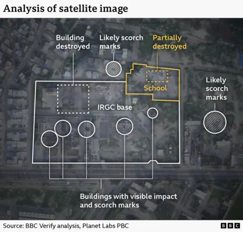
Satellite photos have become a basic tool for verifying what is happening in places that are too dangerous or restricted for reporters and inspectors to reach. When those images are delayed or withheld, the public has fewer independent ways to assess competing narratives from governments and armed groups.
The episode also highlights how powerful a handful of private firms have become in controlling what the world can see from space. A request from one government to one California-based company now affects global visibility into a conflict zone stretching across multiple countries.
Key Facts and Quotes
According to BBC Verify, Planet Labs, a US satellite imagery provider based in California, told customers it had first imposed a 14-day delay on new imagery of Iran and large parts of the Middle East in March. The company has since shifted to what it described as an indefinite restriction.
Planet said its original delay policy was meant “to ensure our imagery is not tactically leveraged by adversarial actors to target allied and NATO-partner personnel and civilians.” In a statement to BBC Verify, the company added that it was moving to a system of “managed distribution,” under which it would release selected images “on a one-off basis until the security risk has abated.”
The request to curb access came from the US government, according to the BBC report. It is not clear what specifically prompted that request, and the US Department of Defense did not respond to a question for comment. Based on BBC Verify’s access to Planet’s online portal, the restriction appears to cover most of the Middle East, including Iran, Iraq, Lebanon, Israel, and Gaza.
One satellite imaging expert told BBC Verify that firms with military or government contracts sometimes follow what are called “voluntary compliance” requests that may, in practice, be reinforced by commercial incentives. Investigative journalist Benjamin Strick, who has worked for several major outlets, said satellite pictures are especially important for “conflict zones, disasters, and other restricted environments where reporters cannot safely access the scene or where information is tightly controlled.”
What It Means for You
For news consumers, the change means there may be fewer independent before-and-after images to test statements about airstrikes, civilian casualties, or damage to infrastructure in the US-Israel conflict with Iran. Reporting may rely more heavily on official releases, occasional leaks, or imagery from other providers, sometimes at lower resolution.
More broadly, the decision raises questions about who controls access to “eyes in the sky” during wartime and crises. How governments and commercial companies balance security concerns against public transparency in this case could set expectations for future conflicts, natural disasters, and human rights investigations worldwide.
How do you think companies and governments should balance security risks with the public’s need for independent information in conflict zones?
Sources
BBC News / BBC Verify report by Matt Murphy, 11 April 2026; Public background information and prior policy descriptions from Planet Labs company materials, accessed October 2024.